Bassett Creek Main Stem Lagoon Dredging Project - Phases I & II
Golden Valley and Minneapolis
Project Number: BC-7
Project Status | Proposed
PHASE II: A scope and budget for the feasibility study were approved by the BCWMC in August 2025 and the study got underway soon thereafter. A public open house on phase II was held on February 19, 2026. The feasibility study was approved in June 2026. Alternative 3 was chosen for implementation. A public hearing on this project will be held on September 17, 2025.
COMPLETED PHASE I: After a detailed feasibility study, in May 2020 the BCWMC approved implementation of the project to dredge all 3 lagoons to a depth of 6 feet (Alternative 2-all). A public hearing was held September 17, 2020; there was no public input received at the hearing and the project was officially ordered by resolution. The project was implemented (designed and constructed) by the BCWMC in close coordination with the Minneapolis Park and Recreation Board. Project design at the 50% phase were approved in December 2021. 90% designs were approved in June 2022. Construction began in early January 2023 and dredging was completed in March. Site restoration was completed in spring/summer 2023. A final report and recommendations for future dredging projects was presented in December 2023.
Project Funding | Grant Funded
The cost of the original project (Phase I) in 2023 was approximately $1.5M with funding coming from a Clean Water Grant ($250,000) from the MN Board of Water and Soil Resources, a $74,000 Hennepin County Opportunity Grant, and funds were collected through ad valorem property taxes collected over 2021, 2022, and 2023 by Hennepin County on property within the Bassett Creek Watershed.
The estimated cost of the second phase of the project is approximately $2.7M. If officially ordered in September 2026, the Commission will use $1.17M remaining in the project budget from Phase I. The remaining funds would come from a levy through Hennepin County on all watershed residents.
Project Description
PHASE I (2023) This project removed sediment that collected in three of the seven “lagoons” created along the Main Stem of Bassett Creek in Wirth Park, between Golden Valley Road and Highway 55. These lagoons were originally created in the mid-1930s by Civilian Conservation Corps crews. A 2015 study found that the lagoons remained relatively unchanged until the early 1990s, when large amounts of sediment began to appear in the lagoons. The sedimentation appeared to slow or stop by the mid-1990s. The sedimentation in Lagoon “E” (immediately to the east of the chalet and parking area) was of concern to City of Minneapolis and Minneapolis Park and Recreation Board (MPRB) staff because the sedimentation may be contributing to flooding of the parking lot and a short section of Theodore Wirth Parkway. The sedimentation resulted in the creation of new “islands” in the creek/lagoons that reduced the flow capacity and floodplain storage of the creek.
The project was originally designed to remove almost 40,000 cubic yards of accumulated sediment by excavating the lagoons to a 6-foot depth. However, the project actually resulted in only the removal of 25,650 cubic yards and a depth of less than 4 feet. Still, the project resulted in a reduction of approximately 390 pounds of total phosphorus and 101,000 pounds of total suspended solids per year that previously flowed downstream in the creek and into the Mississippi River. The cost benefit analysis of the completed project calculates a cost of $210/pound of total phosphorus/year removed. Due to high levels of toxic substances in the sediment, all dredged material required landfill disposal.
Additional project benefits include improved flow capacity and floodplain storage, and improved habitat for fish and macroinvertebrates.
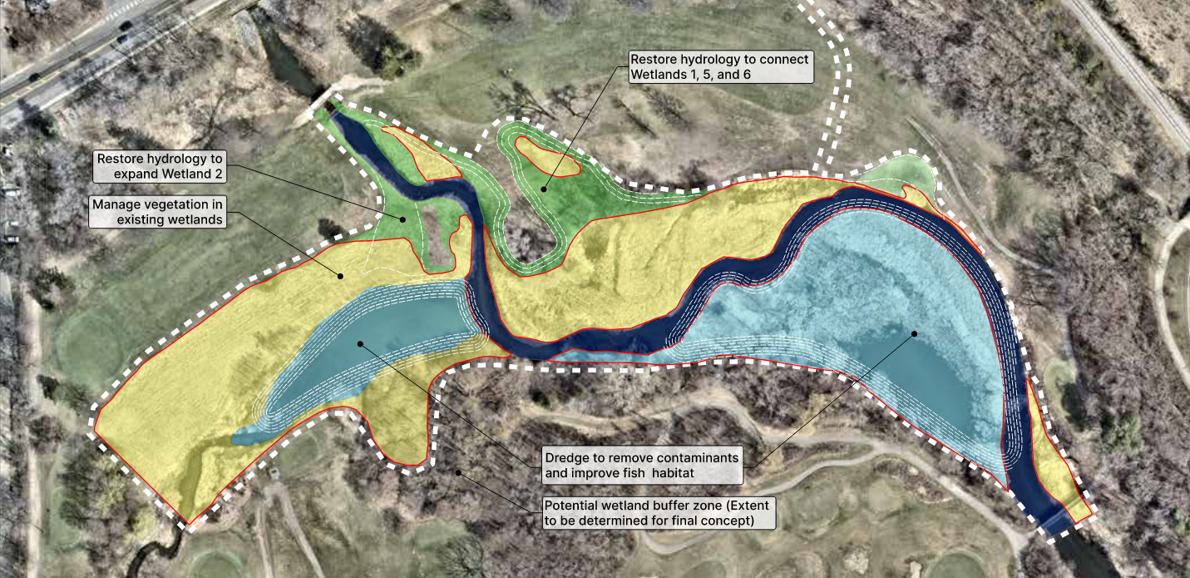
Options for PHASE II of the project were studied in 2026 through a comprehensive feasibility study, including public and MPRB input. Alternative 3 in the study was selected by the BCWMC for implementation and will include dredging of contaminated sediments in Lagoon G along with restoration of adjacent wetlands. If officially ordered in September of this year, the project will result in an estimated annual pollution reduction 363 lbs of total phosphorus and 94,000 lbs of sediment in the creek. The project will create approximately 2.3 acres of open water, remove approximately 1.7 acres of invasive vegetation and replant with native vegetation, remove and dispose of approximately 23,000 cubic yards of contaminated sediment, and create approximately 0.8 acres of improved wetland.
Project Announcements
A public hearing on Phase II of this project will be held on September 17, 2026 at 8:30 a.m. at Golden Valley City Hall
More Information
PHASE II DOCUMENTS:
Final Feasibility Study | Appendices - June 2026
PHASE I DOCUMENTS:
Final Report (Dec 2023)
Project FAQs and Project Flyer
90% Designs and Design Review Memo (June 2022)
EAW Findings of Fact and Record of Decision (Jan 2022)
50% Designs and Design Review Memo (Dec 2021)
Environmental Assessment Worksheet (Nov 2021)
Resolution Ordering the Project (Sept 2020)
Feasibility Study Report (no appendices) (May 2020)
Feasibility Study Report Appendices (May 2020)
Presentation of Feasibility Study (May 2020)
Feasibility Study Proposal (approved July 2019)